Engineering Design and Hydrological Analysis for Effective and Efficient Flood Control
By Engineer John Cee Onwualu (FNSE)
The engineering design of a stormwater drainage system requires a large data collection effort. The data requirements in the stormwater management and control measures for Asaba, Warri, Effurun, and environs include knowledge of topography, drainage boundaries, imperviousness, soil types, and locations of existing drainage channels, manholes, culverts inlets, and outlets.
In addition, identification of other types of utilities and their locations in the ground is critical. These data collated enabled the study and design work for the new drainage network systems to be achieved. The engineering analysis of the drainage system recommended for this project considered four major aspects:
- Hydrological analysis
- Hydraulic analysis.
- Structural analysis of sections
- Bill of Engineering Measurement and Evaluation (BEME)

Hydrological Analysis (Stormwater Estimation)
The design works relied on information provided from rainfall data of over 30 years collated from three meteorological stations (Enugu, Benin, and Onitsha) that are climatically similar and near to Asaba.
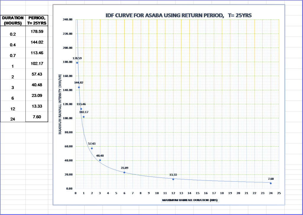
The design works also obtained information from the Federal Ministry of Works, Highway Manual Part 1: Design, for the rainfall Intensity-Duration-Frequency (IDF) Curves for Warri.
The hydrological analysis of the rainfall data for a drainage basin is the most essential in the hydraulic design of drainage facilities.
Intensity-Duration-Frequency (IDF) design curves are used to estimate peak rainfall intensity (I) with different design frequencies (5, 10, 25, 50, and 100) years for the determination of peak Discharge (Qp).